- Home
- FAIR-GNSS methodology

FAIR for GNSS data
FAIR Digital Objects
During this process, FAIR-GNSS will turn ROB’s GNSS data into FAIR Data Objects (FDO), add metadata such as the license of use and
Persistent Identifiers (PID), e.g., using standardized metadata schemes.
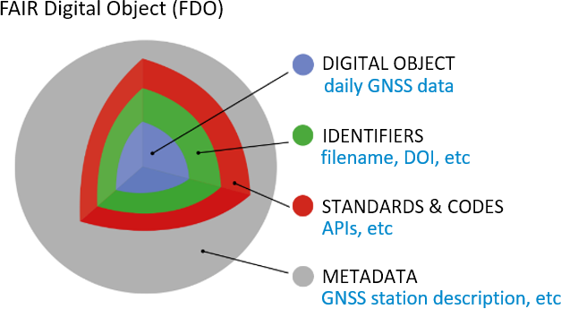 In addition, FAIR-GNSS will facilitate access to the data through the development of APIs (Application Program Interface).
PIDs
Digital Object Identifiers (DOI) are most commonly used as persistent identifiers for data and enable to uniquely identify, trace and cite data. However, the use of PIDs varies within the community, namely DOI are used for stations (UNAVCO), while system handles are used for instruments (SEMISYS). DOI granularity, DOI for dynamic datasets and the assignment of DOIs to queries should also be considered.
Metadata standards
Various metadata schemes and standards are currently in use within the GNSS community. Commonly used formats to store metadata are the IGS site log (ASCII), GeodesyML, GeoJSON, KML and standards such as ISO Geographic information Metadata and Open Geospatial Consortium’s (OGC). A pragmatic approach will be taken to identify the minimal required metadata and metadata scheme. Furthermore, we will investigate current metadata standards and identify necessary adaptations or extensions to already available standards through discussions in the larger GNSS community.
APIs
The GNSS user community is accustomed to download GNSS (meta)data via FTP services and only very recently API, including web services, have started to be available. APIs enable machines to easily access the (meta)data, thus allowing automated data access requests. The API’s will be designed based on a landscape study to investigate e.g., in which format API results should be returned (JSON, JSON-LD, XML, …), existing resources allowing users to get RINEX data and the corresponding station metadata. In addition, interactions with stakeholders will allow us to identify the search criteria (API parameters) a user would prefer to use when searching or downloading GNSS data (RINEX).